Imagen 1 de 3


Galería
Imagen 1 de 3


¿Quieres vender uno?
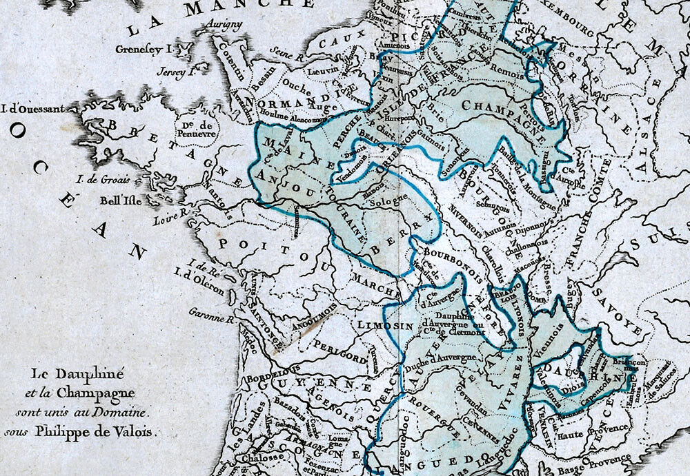
Mapa Zannoni 1766 Francia Dominio Real Philippe de Valois Dauphine Champagne FR-

USD80,00
Aproximadamente68,96 EUR
Costaba USD100,00 (20% de descuento)
Estado:
“Excellent condition for its age, approximately 10x11 inches (25x28cm) on a 11 1/2 x15" (29x38cm) ”... Más informaciónacerca del estado
La oferta finaliza en: 5 d 16 h
- ¡Cómpralo ya!Mapa Zannoni 1766 Francia Dominio Real Philippe de Valois Dauphine Champagne FR
Oops! Looks like we're having trouble connecting to our server.
Refresh your browser window to try again.
Envío:
USD4,99 (aprox. 4,30 EUR) USPS Ground Advantage®.
Ubicado en: Fairview, Pennsylvania, Estados Unidos
Entrega:
Entrega prevista entre el mar. 4 nov. y el lun. 10 nov. a 94104
Devoluciones:
30 días para devoluciones. El vendedor paga el envío de la devolución.
Pagos:
Compra con confianza
El vendedor asume toda la responsabilidad de este anuncio.
N.º de artículo de eBay:405550899632
Características del artículo
- Notas del vendedor
- Cartographer/Publisher
- Rizzi Zannoni
- Printing Technique
- Copper Plate
- Original/Reproduction
- Antique Original
- Format
- Atlas Map
- Type
- Political Map
- Year
- 1766
- Date Range
- 1700-1799
- City
- Paris
- Country/Region
- Belgium, France, Germany, Holland
Descripción del artículo del vendedor
Información de vendedor profesional
Acerca de este vendedor

Lake Erie Antique Maps and Prints
99,8% de votos positivos•40 mil artículos vendidos
Registrado como vendedor profesional
Votos de vendedor (20.039)
- 9***c (117)- Votos emitidos por el comprador.Mes pasadoCompra verificadaExtremely fast shipping. The price was incredible. This seller is on top of their game and I’m definitely going to be buying from them again in the future. Perfectly package said that the documents inside would not be damaged. Even better as described. If you’re looking for the best value on historic documents, this is the place.
- 1***m (15)- Votos emitidos por el comprador.Últimos 6 mesesCompra verificadaVendor good to deal with, second or third time I have bought from them. Item as descried and in good condition Safely packed Delivery time good. Recommend vendor1869 Bartholomew Map Queensland Cape York Melville Brisbane Cairns Australia (#405337580929)
- x***u (161)- Votos emitidos por el comprador.Últimos 6 mesesCompra verificadaMy second order from this seller. As before, the shipping was fast and the map was well packed and protected. Included with the original map was a photocopy of the title page of the book the map came from. Definitely one of my favorite sellers!1836 Gordon Map Syracuse Salina City Plan Mill Pond Salt Company Oswego Canal NY (#365563445498)
Más que explorar:
- Reflectometría de dominio de tiempo,
- Relojes de pulsera Patek Philippe Patek Philippe Nautilus,
- Relojes de pulsera Patek Philippe Patek Philippe Calatrava,
- Calzado de hombre Philipp Plein,
- Relojes de pulsera Patek Philippe Patek Philippe Gondolo,
- Relojes de pulsera Patek Philippe,
- Camisetas de fútbol del Real Madrid,
- Camisetas de hombre negras Philipp Plein,
- Camisetas de fútbol del Real Betis,
- Camisetas de fútbol del Real Sociedad
Lake Erie Antique Maps and Prints
99,8% de votos positivos•40 mil artículos vendidos
Registrado como vendedor profesional
Votos de vendedor (20.039)
- 9***c (117)- Votos emitidos por el comprador.Mes pasadoCompra verificadaExtremely fast shipping. The price was incredible. This seller is on top of their game and I’m definitely going to be buying from them again in the future. Perfectly package said that the documents inside would not be damaged. Even better as described. If you’re looking for the best value on historic documents, this is the place.
- 1***m (15)- Votos emitidos por el comprador.Últimos 6 mesesCompra verificadaVendor good to deal with, second or third time I have bought from them. Item as descried and in good condition Safely packed Delivery time good. Recommend vendor1869 Bartholomew Map Queensland Cape York Melville Brisbane Cairns Australia (#405337580929)
- x***u (161)- Votos emitidos por el comprador.Últimos 6 mesesCompra verificadaMy second order from this seller. As before, the shipping was fast and the map was well packed and protected. Included with the original map was a photocopy of the title page of the book the map came from. Definitely one of my favorite sellers!1836 Gordon Map Syracuse Salina City Plan Mill Pond Salt Company Oswego Canal NY (#365563445498)