Imagen 1 de 4


Galería
Imagen 1 de 4


¿Quieres vender uno?
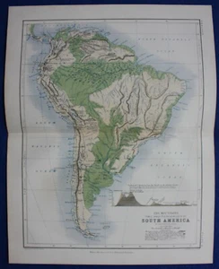
S. AMÉRICA, MONTAÑAS, MAPA FÍSICO, mapa atlas antiguo original, Johnston, 1853-

Estado:
“Excellent condition. Centrefold as published. Light age toning. Original colour. Please study all ”... Más informaciónacerca del estado
Oops! Looks like we're having trouble connecting to our server.
Refresh your browser window to try again.
Envío:
GBP 10,00 (aprox. 11,54 EUR) Royal Mail International Tracked.
Ubicado en: Ilkley, Reino Unido
Entrega:
Entrega prevista entre el vie. 25 jul. y el sáb. 2 ago. a 94104
Devoluciones:
30 días para devoluciones. El comprador paga el envío de la devolución..
Pagos:
Compra con confianza
El vendedor asume toda la responsabilidad de este anuncio.
N.º de artículo de eBay:336065586786
Características del artículo
- Notas del vendedor
- Cartographer/Publisher
- William Blackwood
- Printing Technique
- Lithography
- Date Range
- 1800-1899
- Original/Reproduction
- Antique Original
- Country/Region
- Argentina, Brazil, Chile, Ecuador, Falkland Islands, Peru
- Era
- 1800s
- Format
- Atlas Map
- Type
- Physical Map
- Year
- 1853
Descripción del artículo del vendedor
Información de vendedor profesional
Acerca de este vendedor

Maps etc. Antique Maps & Prints
100% de votos positivos•5,6 mil artículos vendidos
Registrado como vendedor profesional
Votos de vendedor (2.520)
- e***a (70)- Votos emitidos por el comprador.Últimos 6 mesesCompra verificadaI am giving this purchase a 5-star rating, even though the map arrived more than a month late & the shipping tube had been severely mangled (no damage to the contents). Neither problem was the Seller's fault. The shipment was held by US Customs for a month (visible on the tracking documents) without explanation or contact. Seller remained in regular contact, offered to, and then refunded full purchase price during this hiatus. Upon successful delivery, Seller re-invoiced for the map, & I paid.
- r***o (2727)- Votos emitidos por el comprador.Último añoCompra verificadaGreat Seller - This map arrived exactly as described it will be a great addition for my Ancestry research. The map arrived very well packaged and rolled carefully and placed into a postal tube. The delivery was well within the estimated time. I would have no hesitation in recommending this seller to any potential buyers - THANK YOU.PLYMOUTH, DEVONPORT, CITY PLAN, STREET PLAN, original antique map, Bacon, 1884 (#235500514934)
- s***a (368)- Votos emitidos por el comprador.Últimos 6 mesesCompra verificadaMap is exactly as expected and was well packed. First time I have used this seller, but would definitely recommend.BRITISH ISLES, BRITAIN, IRELAND, original antique map, SDUK, published in 1844 (#335838612378)
Más que explorar:
- Libros de mapas y atlas,
- Libros de mapas y atlas con mapa,
- Libros de mapas y atlas en portugués,
- Libros de mapas y atlas en inglés,
- Libros de mapas y atlas en español,
- Libros de mapas y atlas en italiano,
- Mapas de coleccionismo,
- Mapas y software Garmin MAP PILOT para GPS para coches,
- Puzles y rompecabezas, mapas,
- Juegos de mesa, mapas
Maps etc. Antique Maps & Prints
100% de votos positivos•5,6 mil artículos vendidos
Registrado como vendedor profesional
Votos de vendedor (2.520)
- e***a (70)- Votos emitidos por el comprador.Últimos 6 mesesCompra verificadaI am giving this purchase a 5-star rating, even though the map arrived more than a month late & the shipping tube had been severely mangled (no damage to the contents). Neither problem was the Seller's fault. The shipment was held by US Customs for a month (visible on the tracking documents) without explanation or contact. Seller remained in regular contact, offered to, and then refunded full purchase price during this hiatus. Upon successful delivery, Seller re-invoiced for the map, & I paid.
- r***o (2727)- Votos emitidos por el comprador.Último añoCompra verificadaGreat Seller - This map arrived exactly as described it will be a great addition for my Ancestry research. The map arrived very well packaged and rolled carefully and placed into a postal tube. The delivery was well within the estimated time. I would have no hesitation in recommending this seller to any potential buyers - THANK YOU.PLYMOUTH, DEVONPORT, CITY PLAN, STREET PLAN, original antique map, Bacon, 1884 (#235500514934)
- s***a (368)- Votos emitidos por el comprador.Últimos 6 mesesCompra verificadaMap is exactly as expected and was well packed. First time I have used this seller, but would definitely recommend.BRITISH ISLES, BRITAIN, IRELAND, original antique map, SDUK, published in 1844 (#335838612378)