Imagen 1 de 2
Galería
Imagen 1 de 2


¿Quieres vender uno?
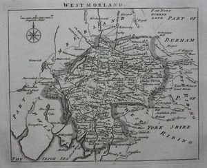
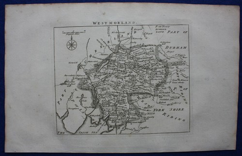
WESTMORLAND, original antique county map, JOHN ROCQUE, 1769

GBP 32,50
Aproximadamente37,30 EUR
Estado:
“Very good condition. Light age toning. Occasional age / handling marks. Please study all the ”... Más informaciónacerca del estado
- ¡Cómpralo ya!WESTMORLAND, original antique county map, JOHN ROCQUE, 1769
Oops! Looks like we're having trouble connecting to our server.
Refresh your browser window to try again.
Envío:
GBP 14,50 (aprox. 16,64 EUR) Economy Int'l Postage.
Ubicado en: Ilkley, Reino Unido
Entrega:
Entrega prevista entre el vie. 17 oct. y el jue. 6 nov. a 94104
Se envía hoy si realizas el pedido en 25 min
Devoluciones:
30 días para devoluciones. El comprador paga el envío de la devolución..
Pagos:
Compra con confianza
El vendedor asume toda la responsabilidad de este anuncio.
N.º de artículo de eBay:335843674548
Última actualización el 28 ago 2025 21:01:58 H.EspVer todas las actualizacionesVer todas las actualizaciones
Características del artículo
- Notas del vendedor
- Antique
- Yes
- County
- Westmorland
- Cartographer/Publisher
- John Rocque
- Printing Technique
- Copper Plate
- Date Range
- 1700-1799
- Original/Reproduction
- Antique Original
- Country/Region
- England
- Era
- 1700s
- Format
- Atlas Map
- Type
- County Map
- Year
- 1769
Descripción del artículo del vendedor
Información de vendedor profesional
Acerca de este vendedor

Maps etc. Antique Maps & Prints
100% de votos positivos•5,6 mil artículos vendidos
Registrado como vendedor profesional
Votos de vendedor (2.572)
- u***z (690)- Votos emitidos por el comprador.Mes pasadoCompra verificadaShipping - super fast. Packaging - professionally packed. Item - as described and in superb condition. Value - worth buying it. Trusted seller and business done smoothly.
- e***a (76)- Votos emitidos por el comprador.Últimos 6 mesesCompra verificadaI am giving this purchase a 5-star rating, even though the map arrived more than a month late & the shipping tube had been severely mangled (no damage to the contents). Neither problem was the Seller's fault. The shipment was held by US Customs for a month (visible on the tracking documents) without explanation or contact. Seller remained in regular contact, offered to, and then refunded full purchase price during this hiatus. Upon successful delivery, Seller re-invoiced for the map, & I paid.Original antique atlas map BRITISH ISLES, GREAT BRITAIN, IRELAND, E Bowen, 1747 (#335916077525)
- 1***1 (704)- Votos emitidos por el comprador.Últimos 6 mesesCompra verificadaReceived very quickly and well packaged. Item as described, excellent seller.N. IRELAND, NEWRY, CASTLEWELLAN, DUNDRUM antique road map, Taylor & Skinner 1778 (#336019391147)
Más que explorar:
- Cromos sueltos de deportes de coleccionismo originales fútbol Derby County,
- CDs de música antique,
- Música, CDs y vinilos antique,
- CDs de música discos antique,
- Mapas y software Garmin MAP PILOT para GPS para coches,
- Mapas y software para GPS para coches,
- Mapas y software para GPS para coches Audi,
- Mapas y software para GPS para coches BMW,
- Mapas y software para GPS para coches Peugeot,
- Mapas y software para GPS para coches Opel
Maps etc. Antique Maps & Prints
100% de votos positivos•5,6 mil artículos vendidos
Registrado como vendedor profesional
Votos de vendedor (2.572)
- u***z (690)- Votos emitidos por el comprador.Mes pasadoCompra verificadaShipping - super fast. Packaging - professionally packed. Item - as described and in superb condition. Value - worth buying it. Trusted seller and business done smoothly.
- e***a (76)- Votos emitidos por el comprador.Últimos 6 mesesCompra verificadaI am giving this purchase a 5-star rating, even though the map arrived more than a month late & the shipping tube had been severely mangled (no damage to the contents). Neither problem was the Seller's fault. The shipment was held by US Customs for a month (visible on the tracking documents) without explanation or contact. Seller remained in regular contact, offered to, and then refunded full purchase price during this hiatus. Upon successful delivery, Seller re-invoiced for the map, & I paid.Original antique atlas map BRITISH ISLES, GREAT BRITAIN, IRELAND, E Bowen, 1747 (#335916077525)
- 1***1 (704)- Votos emitidos por el comprador.Últimos 6 mesesCompra verificadaReceived very quickly and well packaged. Item as described, excellent seller.N. IRELAND, NEWRY, CASTLEWELLAN, DUNDRUM antique road map, Taylor & Skinner 1778 (#336019391147)