Imagen 1 de 1
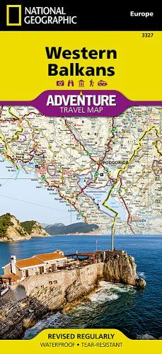
Foto genérica

Imagen 1 de 1
Foto genérica
Western Balkans Adventure Map by National Geographic Maps - Adventure (2022, Sheet Map, Folded)

ZUBER (264194)
97,8% de votos positivos
Precio:
USD28,03
Aproximadamente24,55 EUR
+ USD14,50 de envío
Devoluciones:
30 días para devoluciones. El comprador paga el envío de la devolución..
Estado:
WESTERN BALKANS (NATIONAL GEOGRAPHIC ADVENTURE MAP, 3327) By National Geographic Maps **BRAND NEW**.
- ¡Cómpralo ya!WESTERN BALKANS (NATIONAL GEOGRAPHIC ADVENTURE MAP, 3327) **BRAND NEW**
Oops! Looks like we're having trouble connecting to our server.
Refresh your browser window to try again.
Acerca de este artículo
Product Identifiers
PublisherNational Geographic Maps
ISBN-101566957338
ISBN-139781566957335
eBay Product ID (ePID)243000057
Product Key Features
Edition2022
Book TitleWestern Balkans Adventure Map
Number of Pages1 Pages
LanguageEnglish
TopicEurope / Eastern
Publication Year2022
IllustratorYes
GenreTravel
AuthorNational Geographic Maps-Adventure
Book SeriesNational Geographic Adventure Map Ser.
FormatSheet Map, Folded
Dimensions
Item Weight3.2 Oz
Item Length8 in
Item Width4.3 in
Additional Product Features
Intended AudienceTrade
Series Volume Number3327
Synopsis- Waterproof - Tear-Resistant - Travel Map The Western Balkans region, an adventure playground and rising star of Europe, is loaded with Old World traditions, slow food culture, ancient towns, and rarely visited villages. The area stretches from the Adriatic Sea in the west, up and over mountain ranges, raging rivers, tectonic lakes, steep gorges, and thousands of miles of paths, trails, and routes. Discover eight countries--all with their special brand of Balkan magic: Slovenia, Croatia, Bosnia and Herzegovina, Montenegro, Albania, Serbia, Kosovo, and Macedonia. National Geographic's Western Balkans Adventure Map will meet the needs of travelers with its detailed and accurate information. The map includes the locations of UNESCO World Heritage sites and exotic places to discover, including Slovenia's Triglav National Park, the walled city of Dubrovnik in Croatia, and the World Heritage Lake Ohrid in Macedonia. The map comes with a user-friendly index and clearly marked road network complete with distances and designations for roads/highways, plus secondary routes for those seeking to explore off the beaten path. Start your adventure with a few days, weeks, or months on the 1,200-mile Via Dinarica Trail that traverses the region through the Dinaric Alps and the Sharr Mountain Range. While on the trail--or off--visit one of the many premier national parks: the waterfalls of Plitvice in Croatia; the mountainous Durmitor in Montenegro; Serbia's lush and green Tara, Theth National Park with epic views across the Albanian Alps, and the historic Sutjeska park in Bosnia and Herzegovina. And when it's time for a break, the Balkans are known for their cuisine. Farm-fresh vegetables across Macedonia, savory pastries slow-roasted over an open flame in Kosovo, and delectable seafood up and down the Adriatic coast pairs perfectly with delicious red and white wines from across the entire region. The northern and western portions of the region--stretching from Slovenia, down Adriatic coast, and including Croatia, Montenegro, and Albania--are shown on the front side of the map. The reverse side provides details about the countries on the eastern half of the Western Balkans: Bosnia and Herzegovina, Serbia, Kosovo, and Macedonia. It overlaps the front side, roughly, along the peaks of the Dinaric Alps, which run diagonally from Slovenia to the border between Kosovo and Albania. Every Adventure Map is printed on durable synthetic paper, making them waterproof, tear-resistant and tough -- capable of withstanding the rigors of international travel. Map Scale = 1:800,000 Sheet Size = 25.5" x 37.75" Folded Size = 4.25" x 9.25", Waterproof, Tear-Resistant, Travel Map The Western Balkans region, an adventure playground and rising star of Europe, is loaded with Old World traditions, slow food culture, ancient towns, and rarely visited villages. The area stretches from the Adriatic Sea in the west, up and over mountain ranges, raging rivers, tectonic lakes, steep gorges, and thousands of miles of paths, trails, and routes. Discover eight countries - all with their special brand of Balkan magic: Slovenia, Croatia, Bosnia and Herzegovina, Montenegro, Albania, Serbia, Kosovo, and Macedonia. National Geographic's Western Balkans Adventure Map will meet the needs of travellers with its detailed and accurate information. The map includes the locations of UNESCO World Heritage sites and exotic places to discover, including Slovenia's Triglav National Park, the walled city of Dubrovnik in Croatia, and the World Heritage Lake Ohrid in Macedonia. The map comes with a user-friendly index and clearly marked road network complete with distances and designations for roads/highways, plus secondary routes for those seeking to explore off the beaten path. Start your adventure with a few days, weeks, or months on the 1,200-mile Via Dinarica Trail that traverses the region through the Dinaric Alps and the Sharr Mountain Range. While on the trail - or off - visit one of the many premier national parks: the waterfalls of Plitvice in Croatia; the mountainous Durmitor in Montenegro; Serbia's lush and green Tara, Theth National Park with epic views across the Albanian Alps, and the historic Sutjeska park in Bosnia and Herzegovina. And when it's time for a break, the Balkans are known for their cuisine. Farm-fresh vegetables across Macedonia, savoury pastries slow-roasted over an open flame in Kosovo, and delectable seafood up and down the Adriatic coast pairs perfectly with delicious red and white wines from across the entire region. The northern and western portions of the region - stretching from Slovenia, down Adriatic coast, and including Croatia, Montenegro, and Albania - are shown on the front side of the map. The reverse side provides details about the countries on the eastern half of the Western Balkans: Bosnia and Herzegovina, Serbia, Kosovo, and Macedonia. It overlaps the front side, roughly, along the peaks of the Dinaric Alps, which run diagonally from Slovenia to the border between Kosovo and Albania. Every Adventure Map is printed on durable synthetic paper, making them waterproof, tear-resistant and tough - capable of withstanding the rigours of international travel. Scale: 1:800,000


