Imagen 1 de 2

Galería
Imagen 1 de 2


¿Quieres vender uno?
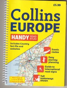
COLLINS EUROPE HANDY ROAD ATLAS (2012 SPIRAL BOUND){Z1}

USD16,00
Aproximadamente13,76 EUR
Estado:
Nuevo
Libro nuevo, sin usar y sin leer, que está en perfecto estado; incluye todas las páginas sin defectos. Consulta el anuncio del vendedor para obtener más información.
Más de 10 disponibles1 vendido
- ¡Cómpralo ya!COLLINS EUROPE HANDY ROAD ATLAS (2012 SPIRAL BOUND){Z1}
Oops! Looks like we're having trouble connecting to our server.
Refresh your browser window to try again.
Envío:
Gratis USPS Media MailTM.
Ubicado en: Oakville, Connecticut, Estados Unidos
Entrega:
Entrega prevista entre el mié. 15 oct. y el mar. 21 oct. a 94104
Devoluciones:
No se aceptan devoluciones.
Pagos:
Compra con confianza
El vendedor asume toda la responsabilidad de este anuncio.
N.º de artículo de eBay:256338746947
Características del artículo
- Estado
- Ex Libris
- No
- Narrative Type
- Nonfiction
- ISBN
- 9780007364138
Acerca de este producto
Product Identifiers
Publisher
HarperCollins The Limited
ISBN-10
000736413X
ISBN-13
9780007364138
eBay Product ID (ePID)
13038199710
Product Key Features
Edition
2
Book Title
Collins Handy Road Atlas Europe
Number of Pages
180 Pages
Language
English
Topic
Maps & Road Atlases (See Also Reference / Atlases, Gazetteers & Maps), Europe / General
Publication Year
2012
Illustrator
Yes
Genre
Travel
Book Series
International Road Atlases Ser.
Format
Spiral
Dimensions
Item Height
0.6 in
Item Weight
10.6 Oz
Item Length
8.7 in
Item Width
6.1 in
Additional Product Features
Intended Audience
Trade
Dewey Edition
23
Dewey Decimal
912.4
Edition Description
New Edition,Revised edition
Synopsis
A handy format road atlas of Europe at 34 miles to 1 inch with lie-flat spiral binding, ideal for both drivers and those traveling by public transport Every major European country is covered in this fully updated road atlas that features a ratio of 34 miles to one inch. Euroroutes and highways are clearly identified as are all international road classifications, scenic routes, and common resorts. A route planning map, information on road signs, country fact files, and a full index of place names complete this ideal travel companion., Scale: 1:2,000,000 Handy road atlas of Europe at A5 format with lie-flat spiral binding. Ideal format for both drivers and those travelling by public transport. Scenic routes are plotted on the maps., Scale: 1:2,000,000 Handy road atlas of Europe at A5 format with lie-flat spiral binding. Ideal format for both drivers and those travelling by public transport. Scenic routes are plotted on the maps. MAIN FEATURES Handy A5 format road atlas of Europe at 34 miles to 1inch. Euroroutes and motorways are easily distinguished on the mapping. The maps also show international road classifications, road distances in kilometres and land height is shown by attractive layer tints. INCLUDES * Route planning maps at 1:6,340,000 with political colouring. * Country fact file. * Distance map and chart. * Information on international road signs. * Main road maps at 1:2,174,000. * Each page has a little locator diagram to help you pinpoint where you are in relation to the rest of Europe. * Full index to place names. * Full updates including new motorways in Ireland, France and Hungary. The maps include: - scenic routes - Euro route numbers WHO THE PRODUCT IS OF INTEREST TO Motorists planning a journey in Europe and for use en route. It is also ideal for those travelling by public transport who would like a neat portable atlas to take with them., Scale: 1:2,000,000 Handy road atlas of Europe at A5 format with lie-flat spiral binding. Ideal format for both drivers and those travelling by public transport. Scenic routes are plotted on the maps. MAIN FEATURES Handy A5 format road atlas of Europe at 34 miles to 1inch. Euroroutes and motorways are easily distinguished on the mapping. The maps also show international road classifications, road distances in kilometres and land height is shown by attractive layer tints. INCLUDES Route planning maps at 1:6,340,000 with political colouring. Country fact file. Distance map and chart. Information on international road signs. Main road maps at 1:2,174,000. Each page has a little locator diagram to help you pinpoint where you are in relation to the rest of Europe. Full index to place names. Full updates including new motorways in Ireland, France and Hungary. The maps include: scenic routes Euro route numbers WHO THE PRODUCT IS OF INTEREST TO Motorists planning a journey in Europe and for use en route. It is also ideal for those travelling by public transport who would like a neat portable atlas to take with them.
Descripción del artículo del vendedor
Información de vendedor profesional
Acerca de este vendedor

paperdragon860
99,9% de votos positivos•31 mil artículos vendidos
Registrado como vendedor profesional
Votos de vendedor (11.167)
- 8***2 (1034)- Votos emitidos por el comprador.Mes pasadoCompra verificadaArrived safely, as described, great tracking, took 18 days to ship to the UK. Very happy, great seller
- a***s (882)- Votos emitidos por el comprador.Mes pasadoCompra verificadaAmazing seller. Received the DVD very quickly. The DVD was as advertised (new), packed very carefully and with great care. The DVD arrived in excellent condition and available for a great price considering it's an out of print title.
- a***5 (3)- Votos emitidos por el comprador.Último añoCompra verificadaGreat experience purchasing from them. The item arrived so well packed and secured that it took me around 5+ minutes just to open fully. Condition was as advertised (photos were accurate), price was exceptional, and the item was delivered ahead of schedule. I hope to be able to buy from them again!TESTAMENT: THE LIFE AND ART OF FRANK FRAZETTA (2008 Softcover){G4} (#256532914665)
Más que explorar:
- Libros infantiles y juveniles Suzanne Collins,
- Libros atlas,
- Libros de texto, educación y referencia collins,
- Libros de texto, educación y referencia Collins, en inglés,
- Libros de mapas y atlas,
- Libros de mapas y atlas con mapa,
- Libros de mapas y atlas 2000 - 2009,
- Libros de mapas y atlas con mapa, en francés,
- Libros de mapas y atlas michelin en inglés,
- Libros de mapas y atlas con mapa Michelin
paperdragon860
99,9% de votos positivos•31 mil artículos vendidos
Registrado como vendedor profesional
Votos de vendedor (11.167)
- 8***2 (1034)- Votos emitidos por el comprador.Mes pasadoCompra verificadaArrived safely, as described, great tracking, took 18 days to ship to the UK. Very happy, great seller
- a***s (882)- Votos emitidos por el comprador.Mes pasadoCompra verificadaAmazing seller. Received the DVD very quickly. The DVD was as advertised (new), packed very carefully and with great care. The DVD arrived in excellent condition and available for a great price considering it's an out of print title.
- a***5 (3)- Votos emitidos por el comprador.Último añoCompra verificadaGreat experience purchasing from them. The item arrived so well packed and secured that it took me around 5+ minutes just to open fully. Condition was as advertised (photos were accurate), price was exceptional, and the item was delivered ahead of schedule. I hope to be able to buy from them again!TESTAMENT: THE LIFE AND ART OF FRANK FRAZETTA (2008 Softcover){G4} (#256532914665)