Imagen 1 de 4


Galería
Imagen 1 de 4


¿Quieres vender uno?
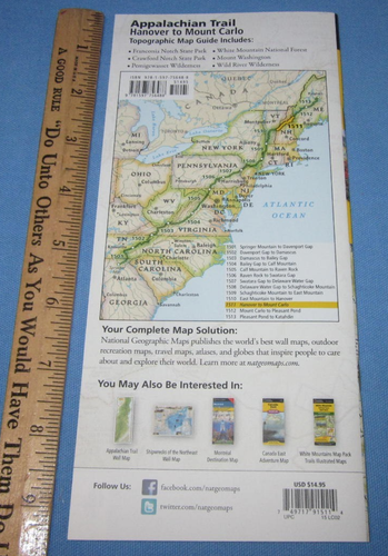
Appalachian Trail Topographic Map Guide Hanover to Mount Carlo by Nat Geo

Troll's Basement Bizarre
(40415)
Vendedor particular
USD11,95
Aproximadamente10,26 EUR
Estado:
- ¡Cómpralo ya!Appalachian Trail Topographic Map Guide Hanover to Mount Carlo by Nat Geo
Oops! Looks like we're having trouble connecting to our server.
Refresh your browser window to try again.
Envío:
Gratis USPS Ground Advantage®.
Ubicado en: Temple, Georgia, Estados Unidos
Entrega:
Entrega prevista entre el mié. 10 dic. y el lun. 15 dic. a 94104
Devoluciones:
30 días para devoluciones. El comprador paga el envío de la devolución..
Pagos:
Compra con confianza
Sobre este artículo
El vendedor asume toda la responsabilidad de este anuncio.
N.º de artículo de eBay:317310105323
Última actualización el 29 sep 2025 13:41:11 H.EspVer todas las actualizacionesVer todas las actualizaciones
Características del artículo
- Estado
- Vintage
- No
- ISBN
- 9781597756488
Acerca de este producto
Product Identifiers
Publisher
National Geographic Maps
ISBN-10
1597756482
ISBN-13
9781597756488
eBay Product ID (ePID)
215345199
Product Key Features
Edition
2022
Book Title
Appalachian Trail, Hanover to Mount Carlo [New Hampshire]
Number of Pages
1 Pages
Language
English
Topic
United States / Northeast / New England (Ct, mA, Me, NH, Ri, VT), Maps & Road Atlases (See Also Reference / Atlases, Gazetteers & Maps), Special Interest / Hikes & Walks, Hiking
Publication Year
2022
Illustrator
Yes
Genre
Travel, Sports & Recreation
Book Series
National Geographic Topographic Map Guide Ser.
Format
Sheet Map, Folded
Dimensions
Item Weight
2.9 Oz
Item Length
9.4 in
Item Width
4.3 in
Additional Product Features
Intended Audience
Trade
Series Volume Number
1511
Synopsis
Waterproof, tear-resistant topographic map guide. The Hanover to Mount Carlo Topographic Map Guide makes a perfect traveling companion when traversing the New Hampshire section of the Appalachian Trail. Each A.T. Topographic Map Guide includes detailed topographic maps at a detail of 1 inch equals 1 mile. Each page is centered on the A.T. and overlaps with the adjacent pages so there is little chance of getting lost. Along the bottom of each page is a trail profile that shows the distance between shelters, camping areas, and trail access points., - Waterproof - Tear-Resistant - Topographic Map The Hanover to Mount Carlo Topographic Map Guide makes a perfect traveling companion when traversing the New Hampshire section of the Appalachian Trail (A.T.). The A.T. through New Hampshire is considered one of the more challenging sections of the trail, with long stretches above tree line and the possibility for rapid temperature change and snow any month of the year. But despite its difficulty, the trail offers some of the most spectacular scenery in New England as it leaves the Connecticut River valley to traverse the beautifully rugged White Mountains, a highlight of the A.T. Each A.T. Topographic Map Guide includes detailed topographic maps at a detail of 1 inch = 1 mile. Each page is centered on the A.T. and overlaps with the adjacent pages so there is little chance of getting lost. Along the bottom of each page is a trail profile that shows the distance between shelters, camping areas, and trail access points. The map and trail profile provide a step by step visual guide to hiking the trail, mile by rugged mile. The Topographic Map Guide is built for all levels of hiking enthusiasts, from the day tripper to the multi month 'thru-hiker'. The front pages of the printed Topographic Map Guide include resupply information, town inset maps, camping options, and much more. Every Topographic Map Guide is printed on "Backcountry Tough" waterproof, tear-resistant paper. A full UTM grid is printed on the map to aid with GPS navigation. Other features found on this map include: Beaver Brook Shelter, Berlin, Carlo Col Shelter, Carter Dome, Carter Notch Shelter, Connecticut River, Crawford Notch State Park, Eliza Brook Shelter, Ethan Pond Shelter, Fire Warden's Cabin Shelter, Franconia Notch State Park, Full Goose Shelter, Galehead Shelter, Garfield Ridge Shelter, Gentian Pond Shelter, Gorham, Greenleaf Shelter, Guyot Shelter, Hanover, Hexacuba Shelter, Imp Shelter, Jeffers Brook Shelter, Kinsman Pond Shelter, Lakes of the Clouds Shelter, Lebanon, Lonesome Lake Shelter, Ludlow, Lyme, Madison Spring Shelter, Mahoosuc Arm, Mizpah Spring Shelter, Moose Mountain Shelter, Mount Carlo, Mount Cube, Mount Lafayette, Mount Madison, Mount Moosilauke, Mount Moriah, Mount Washington, North Woodstock, Norwich, Pinkham Notch, Rattle River Shelter, Smarts Mtn, Speck Pond Shelter, Trapper John Shelter, Velvet Rocks Shelter, White Mountain National Forest, White River Junction, Zealand Falls Shelter . Map Scale = 1:63,360 Folded Size = 4.25" x 9.25"
Descripción del artículo del vendedor
Acerca de este vendedor

Troll's Basement Bizarre
99,9% de votos positivos•92 mil artículos vendidos
Registrado como vendedor particularPor tanto, no se aplican los derechos de los consumidores derivados de las leyes de protección de los consumidores de la UE. La Garantía al cliente de eBay sigue aplicando a la mayoría de compras. Más informaciónMás información
Votos de vendedor (41.839)
- y***g (434)- Votos emitidos por el comprador.Mes pasadoCompra verificadaSuper cool Radio Shack semi truck rc. Brand new exactly as described. Good price considering it’s a vintage rc as well. The best packaging I’ve ever seen on any order. Great care was taken to ensure nothing was damaged in transit and everything arrived perfect. Shipping time was fast. Couldn’t be happier. Awesome seller!
- k***n (2213)- Votos emitidos por el comprador.Últimos 6 mesesCompra verificadaFast shipping which is appreciated. Well packaged, which is also appreciated since the post office and other carriers seem to destroy every package nowadays. It doesn't matter if it's USPS, UPS or Fed X, In Florida they destroy every package they handle. Almost every package i receive is either torn open, crushed, mutilated or destroyed. This product/package arrived intact, safe and undamaged because this seller packaged it well. Got a good deal and would recommend this seller.Appalachian Trail Topographic Map Guide Davenport Gap to Damascus by Nat Geo (#365828994034)
- a***h (70)- Votos emitidos por el comprador.Mes pasadoCompra verificadaItems as described, new in packaging. Great price, super fast shipping, well packaged parcel. These Made in the USA cups keep ice and beverages cold all day long! Well made, sturdy mugs.
Más que explorar:
- Libros de mapas y atlas,
- Libros de mapas y atlas en inglés,
- Libros de mapas y atlas en portugués,
- Libros de mapas y atlas con mapa,
- Libros de mapas y atlas en español,
- Libros de mapas y atlas en francés,
- Libros de mapas y atlas en italiano,
- Libros de mapas y atlas en alemán,
- Libros de mapas y atlas michelin,
- Libros de mapas y atlas de tapa blanda
Troll's Basement Bizarre
99,9% de votos positivos•92 mil artículos vendidos
Registrado como vendedor particularPor tanto, no se aplican los derechos de los consumidores derivados de las leyes de protección de los consumidores de la UE. La Garantía al cliente de eBay sigue aplicando a la mayoría de compras. Más informaciónMás información
Votos de vendedor (41.839)
- y***g (434)- Votos emitidos por el comprador.Mes pasadoCompra verificadaSuper cool Radio Shack semi truck rc. Brand new exactly as described. Good price considering it’s a vintage rc as well. The best packaging I’ve ever seen on any order. Great care was taken to ensure nothing was damaged in transit and everything arrived perfect. Shipping time was fast. Couldn’t be happier. Awesome seller!
- k***n (2213)- Votos emitidos por el comprador.Últimos 6 mesesCompra verificadaFast shipping which is appreciated. Well packaged, which is also appreciated since the post office and other carriers seem to destroy every package nowadays. It doesn't matter if it's USPS, UPS or Fed X, In Florida they destroy every package they handle. Almost every package i receive is either torn open, crushed, mutilated or destroyed. This product/package arrived intact, safe and undamaged because this seller packaged it well. Got a good deal and would recommend this seller.Appalachian Trail Topographic Map Guide Davenport Gap to Damascus by Nat Geo (#365828994034)
- a***h (70)- Votos emitidos por el comprador.Mes pasadoCompra verificadaItems as described, new in packaging. Great price, super fast shipping, well packaged parcel. These Made in the USA cups keep ice and beverages cold all day long! Well made, sturdy mugs.